Many people have heard about “The Wave” or the North Coyote Buttes and certainly have seen pictures of it. The same is not so much applicable to South Coyote Buttes. That is a shame! The latter is at least as beautiful and attractive as the North Coyote Buttes if not more. On the other hand this is a huge plus. It is relatively easy to get a permit to this area and you will have a great time hiking and photographing a most unique landscape.
Getting to South Coyote Buttes is not very easy (we will get to it momentarily) and for an in-depth visit you will have to plan in at least one overnight camp or even more if you include a visit to the close by White Pocket.
The South Coyote Buttes have two different sections. The more readily accessible Paw Hole and the little more distant Cottonwood Cove. Both are worth every minute spent there, although I have a personal preference for the latter. You will need to spend quite a bit of time hiking in the South Coyote Buttes to explore the area thoroughly. To be there first thing in the morning I recommend camping at Cottonwood, just outside the wilderness area, where low impact backcountry camping is allowed. The best place to do so is near the corral at Cottonwood Cove trailhead. This allows you to explore and photograph until sunset and to catch sunrise at the heart of the buttes. In this case you will need to plan ahead and get a permit for two consecutive days.
Getting a permit to South Coyote Buttes is relatively easy and not to be compared at all with the North Coyote Buttes process. You can order your permit online by entering your days in a calendar. This needs to be done 3 months prior to your visit. The permit will be sent to you via snail mail.
Getting to the South Coyote Buttes:
You will receive a map with all the details once you get your permit. However, be well advised that a 4WD vehicle in good mechanical condition is absolutely mandatory! Additionally the vehicle should have an extra clearance. The ‘road’ to Paw Hole and Cottonwood Cove has patches of DEEP sand along the way. Deep sand is hard enough to cross when the terrain is flat. When you have to climb hills (and you will have to), it can get extremely difficult, especially when previous cars have made deep ruts. Believe me, I know what I am talking about. My first visit to the area I got stuck on a hill and getting the vehicle out of this predicament was not an easy job. Lowering the tire inflation by about a third can increase the flotation and gain better traction, but make no mistake, this little trick is not a guarantee that everything will go smoothly. Be sure to re-insufflate your tires when you return to the pavement. The number one rule while driving in deep sand is: DO NOT STOP. Try to maintain a constant speed at high revs. If there are deep ruts, turn your wheels slightly from side to side to avoid getting buried too low. The best time to drive through deep sand is after rain when the sand is packed and traction is better. Have a shovel with on your trip. This is your best line of defense if you get stuck it will work.
Paw Hole:
Coming from the north via US 89 means a 16 miles drive on the House Rock Valley Road, passing the Wire Pass trailhead and the Stateline Campground until you enter an unmarked dirt road leading east to the Lone Pine Tree Reservoir. After another 2.5 miles from the House Rock Valley Road you will reach the Paw Hole trailhead. Park at the pullout and follow the marked trail toward the first group of Paw Hole Teepees. The adventure is about to start!
With a 4WD vehicle, it is unlikely that you will get stuck along this section of the sandy track between Lone Pine Tree Reservoir and Paw Hole. It will provide a good test to evaluate whether you can risk it to the more difficult Cottonwood Cove area.
The south access is from US 89A and takes a 11.5 miles drive until reaching the above mentioned unmarked dirt road leading east to the Lone Pine Tree Reservoir.
Cottonwood Cove: To get to this remote area you have a couple of options. If your are coming from the north and your choice is to explore first Paw Hole the logical sequence would be following the same sand road east ( BLM 1079) that took you to Paw Hole. About 1 mile later you will reach a gate that needs to be closed once you passed it. By the way, all gates that you encounter during this trip will need to be closed after you passed them. The entire area has cattle and things can get quite difficult for future visitors if cattle start going stray and the farmers would obviously not be pleased. After another mile you will get to a junction and turn left (north) on road BLM 1082. You will reach a corral and a gate after 1.3 miles after which you will end up at the Cottonwood Cove trailhead. Park there and follow all the other footsteps heading northwest.
Coming from US 89A (south) makes things a little bit different. Drive 8.5 miles on the House Rock Road and enter right (east) on BLM 1017. After 2 miles you will merge onto BLM 1066 and shortly after onto BLM 1081. Once you reach famous Poverty Flat Ranch with its corral and windmill you will swith onto BLM 1079 heading west for another 0.5 miles and finally getting to the junction with BLM 1082 to your right heading north. From this point you will follow the same instructions already given above until you get to Cottonwood Cove trailhead.
Taking shots:
Paw Hole:
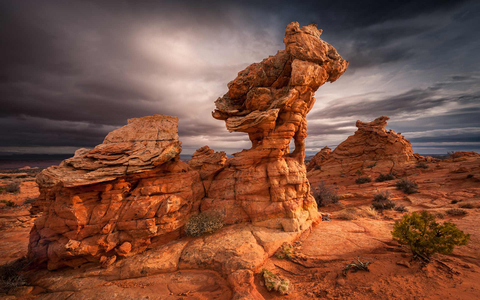
From the beginning of the trailhead you have a great view of the red teepees at sunset, but that is probably putting the carriage in front of the horse because you probably will start to explore this entire area in the morning and not in the evening. Anyway, a short walk on this trail leads you through the heart of the lower Paw Hole Teepees. You can climb behind the lower teepees and find several good spots to photograph them at close range, looking south and eye-level with the teepees. Proceeding past the lower teepees in a northeasterly direction, you will loose the trail. That is not a problem, because now you are entering an open area with interesting formations where you can spend quite a bit of time photographing.
Retrace your steps to the south of the lower teepee and circumnavigate them to the left in a northerly direction. Follow the western edge of the escarpement along the boundary of the permit area. Continue in this direction for about 1 mile. You will come to a particularly interesting area. The rocks look like lace and are very fragile. Do not walk on them and do not touch it. This area is especially nice to be photographed in the late afternoon with the sun in your back. Continuing your hike in the same northerly direction will take you to a huge drop in the landscape from where you will see Cottonwood Cove to your right and to your left the North Coyote Butte Teepees. This panorama is overwhelming of beautiful and is best photographed at sunset. However, just remember that you will need to return all the way back to your car. A GPS and a headlight can be quite useful to retrace your steps in the increasing darkness.
Cottonwood Cove:
So, you really want to go there and you actually got there!? The trail leads you west into the heart of the Cottonwood Cove. It takes about a 0.5 miles hike to enter a wonderland of weird formations, colors, crossbedding, striations and much more. I encourage you to make your own adventure and find photographic places for yourself. Just hike around the buttes, get familiar with the topography, climb up to get a bird’s eye view, follow tracks and you will discover all the best places by yourself. Finding the different geologic features and formations will give you a special and unique meaning, compared to providing you with GPS waypoints. I recommend planning a comprehensive exploration of the entire area by making a wide loop in a roughly counterclockwise direction.
I really believe that you need 2-3 days permit to explore the entire area of the South Coyote Butte in a satisfactory manner and have several opportunities of sunrise and sunset moods to enhance your photography. I have been there three times now and still have the feeling that there is so much more to be discovered and photographed. May 2011 I will be returning there for my fourth and certainly not the last trip!
Last update: August 11, 2017
