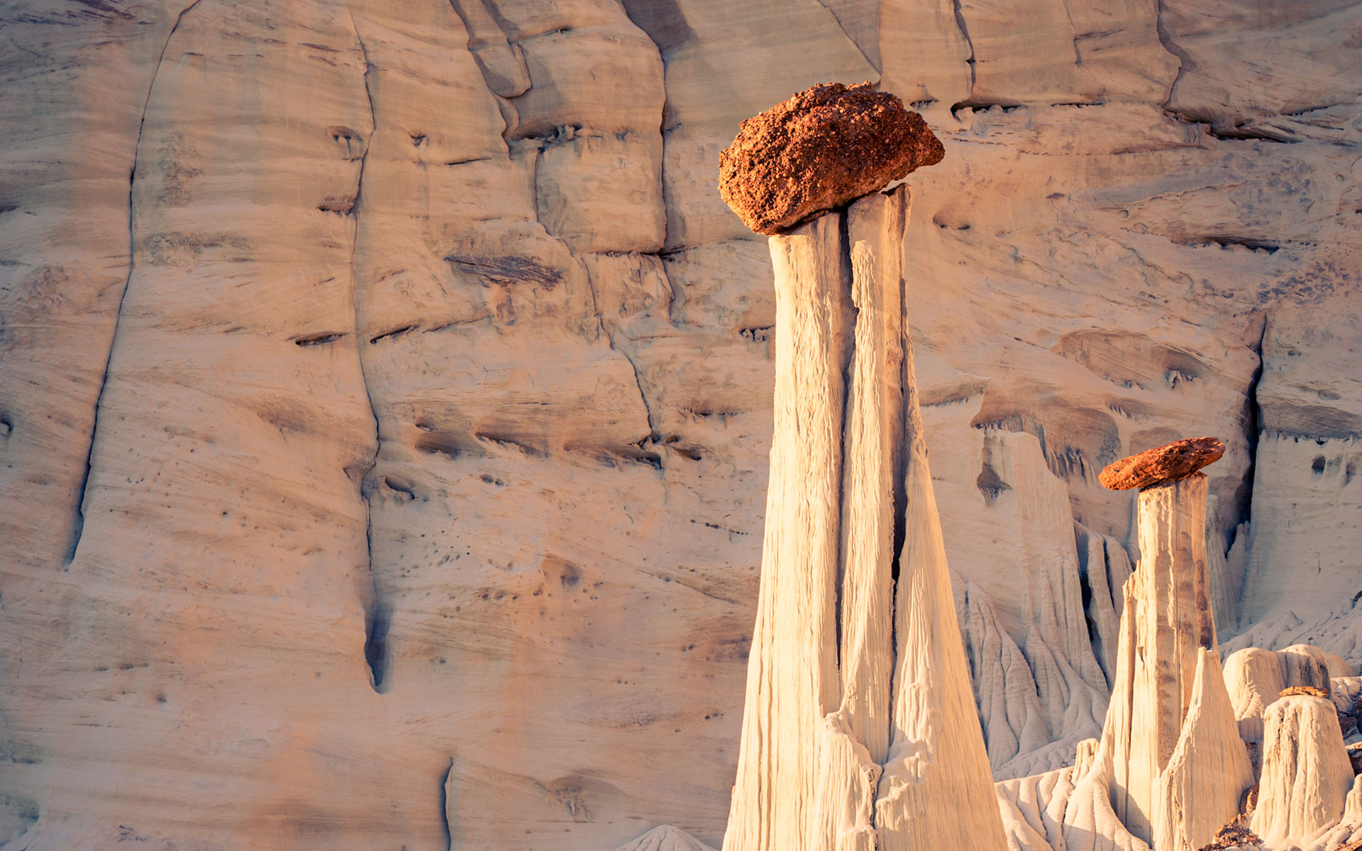
The Wahweap Hoodoos are the most elegant and fascinating hoodoos that I have seen so far. The trip and hike is absolutely worthwhile! The place is a well kept secret for those that know its exact location. The famous photographer Michael Fatali was one of the first to photograph these hoodoos. I believe he also was the one that coined its name “Towers of Silence”.
Once you see Fatali’s photograph as well as other photographs of these unique hoodoos you will feel its magic instantaneously and will not stop searching for its location until you get there. At least that is what happened to me. My first attempt to get there, my wife and I hiked an entire day into the wrong direction. At the end we saw many interesting formations, but not the hoodoos. However, persistence pays off and next day we returned with our hunt and were blessed by the absolute enchanting view of these most delicate and impressive hoodoos.
Practical advices:
Summer is clearly too hot! The best period in the year is Spring or Autumn. If you are planning to be there in the early morning at sunrise I would recommend to either hike in late afternoon and camp there, or get acquainted with the hike during daylight to ensure that you will find your way in the dark of the next early morning. A flashlight is mandatory under these circumstances.
If you decide to take the south access you need to have some extra water in your backpack, especially if you are stubborn enough to go during summer.
Getting to the Wahweap Hoodoos:
There are two ways to get to the Wahweap Hoodoos, although the two times I got there I only used the ‘official’ one that is provided at the BLM Visitor Center in Big Water.
North Access: I never took this route, but I know that it is the shorter and more comfortable (at least for you legs, but not necessarily for your car) way to get to the Wahweap Hoodoos. Both times that I went to the hoodoos I met people that came this way and their explanation that it is only a mile or less of hiking sounded very promising.
From US 89, about 10.4 miles west of Big Water, take Cottonwood Canyon Road for about 1 1/2 mile, turn right onto BLM Road 431 and follow it for about 4 miles until the junction with Brigham Plains Road (BLM 430). This is a fairly good road, except or the crossing of Coyote Creek near the last junction, which can be rough in some years. At the junction, take the right fork and follow BLM 431 straight ahead, bearing east and following the most heavily used tracks. 1/2 mile after passing Coyote Creek, you will reach a stock pond with a dam. After this point the road is poorly maintained. Be sure to drive very slowly and carefully. At about 8 miles from Cottonwood Canyon Road, you will pass the White Sands Jeep Road to your right; stay on the main track, going east. After about another mile, BLM 431 descends into a vast depression, at the bottom of which continues eastward for another mile or so toward Wahweap Wash. Just before entering the wash you will see a sign prohibiting driving into the wash. Park your vehicle here and continue south on foot for about 20 minutes. The first group of hoodoos is located 1 mile downstream and to the right. The exact GPS coordinate is given below.
South Access: This is the official route provided at the BLM Center in Big Water. It is also the longer way to get there. Given the fact of the fragility of the site it is probably understandable that BLM does only provide this route. Distance and difficulty of access is a clear hindrance for all the ones that are not in the mood for a real adventure and this protects the environment from an invasion and destruction of it as it is happening for example at the extreme easy access Toadstool Hoodoos.
The trip starts from the little community of Big Water (UT) located north of Page (AZ) on Hwy. US 89. Drive through the town and at the Y with Smoky Mountain Road , bear left on Nipple Creek Road (BLM 327) heading northwest. Follow it along the ponds of the Fish Hatchery until you reach the Wahweap crossing. Park there along the right side of the road, or if the stream is not high and you have got a high clearance vehicle cross the wash heading north for about half mile until you reach a parking space to your right. From US 89 until this parking place it is about 4.5 miles. Leave your car here.
Now starts the hiking adventure. You will see a trail leading north. To your left you will see the imposing Wahweap Wash. Descend the bluff to enter the wash and head north. After half mile you will pass a fence crossing the entire wash. Walk in the Wahweap Wash for almost 4 miles until you find the first hoodoos. The walking is easy and it will take about 1 1/2 hours to get there at a normal pace.
There are three groups of hoodoos along the cliff to your left (west). Each group is separated from the others by a couple hundred yards. Do not concentrate too much at the first group. You will be much better served at the second group and even better at the last group – the Towers of Silence.
The exact GPS location of it is: N37 09’45” W111 42’45” and below you have the link to a map that will lead your way safely.
Taking shots:
All the Wahweap Hoodoos are best photographed from sunrise to early morning regardless of season. During winter months, however, there is no direct light on the Towers of Silence but a very nice soft light instead. In summer, the Towers are directly illuminated from sunrise on while the tall siltstone cliff in the background remains in the shadow. This allows for nice contrasts between the hoodoos and the background making the Towers stand out.
Just one hour after sunrise the light is already to harsh and the soft details in the texture of the siltstone gets lost!
The soft sunset light might give some interesting colors in the sky, although I have to admit that I did not experiment it, yet.
Last update: Oct. 26, 2010
