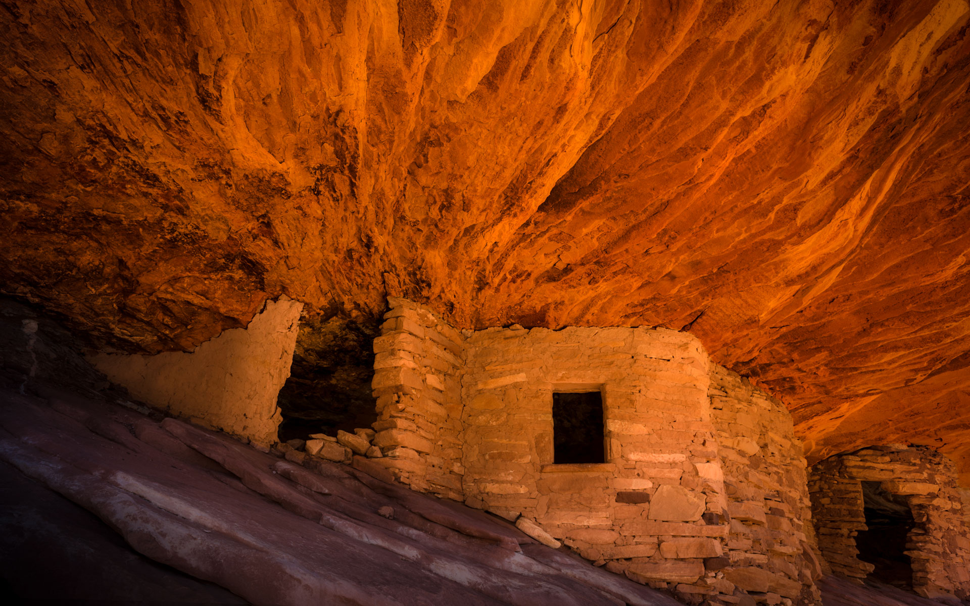
House on Fire was probably the first Ancient Puebloan ruin that put Cedar Mesa on the map through the famous American landscape photographer David Muench. His photograph of the ruin with very appealing warm colors and the texture of the ceiling evoking the feeling of fire provides a huge impact on anyone who sees Muench’s image. Since then many followers visited this ruin and its proximity to the road and just a short hike certainly contribute for this ruin to be probably the most photographed of all of Cedar Mesa.
A visit of this ruin and photographing it are highly recommendable!
Practical advices:
The easiness of the hike and its proximity to the parking lot almost gives no excuse to avoid a visit of this ruin even during the high summer temperatures. Just make sure that you carrying some water with you under such circumstances.
Getting to House on Fire Ruin:
The road leading to the trailhead for House on Fire is located on Co. Rd 263 which is about halfway between the town Blanding and Natural Bridges National Monument near mile marker 102 on the north side of Hwy 95. If you’re coming from the west it’s very easy to find. Thirteen miles after the intersection of Hwy 261 and 95 ou will see a sign for ‘Mule Canyon, Indian Ruins‘ – this is NOT where House on Fire is located. As soon as you pass this, the turn for House on Fire will be your next left. If you’re coming from the east, it’s the next right after mile marker 102.
Turn north onto 263 and you will immediately see a BLM Monticello kiosk. This is where you can pay for your backcountry permit to hike to House on Fire. Backcountry permit fees are $2/person, or if you will be spending some time hiking in the area, you can also purchase a week permit for $5/person.
After purchasing your permit, continue down the road approximately 0.3 miles and you will see a small turnout for parking on the right-hand side (N37.537333 W109.732010) and the trailhead marker on the left (west, across the road and down into the canyon).
The hike is a very easy one. Walk along the canyon for about 20 minutes (5/6 mile). The ruin will be located right-hand some 30 feet above the canyon floor. The climb is easy and the point is marked with a cairn (N37.543900 W109.74606).
Photographic advices:
There is a very particular moment of the day to be at House on Fire Ruin. The sunlight has to reflect from the canyon in mid-morning to cast a warm glow on the alcove. Avoid early morning or after sunset as the light is dull. After mid-day the sun shines into the alcove and the contrast will be a real killer.
The optimal lens is in the range of 24-70mm.
Last update: February 25, 2015
