Coyote Gulch is located in a remote section of the Glen Canyon National Recreation Area. It is one of the most popular destinations in southern Utah. Its natural beauty draws in nature photographers.
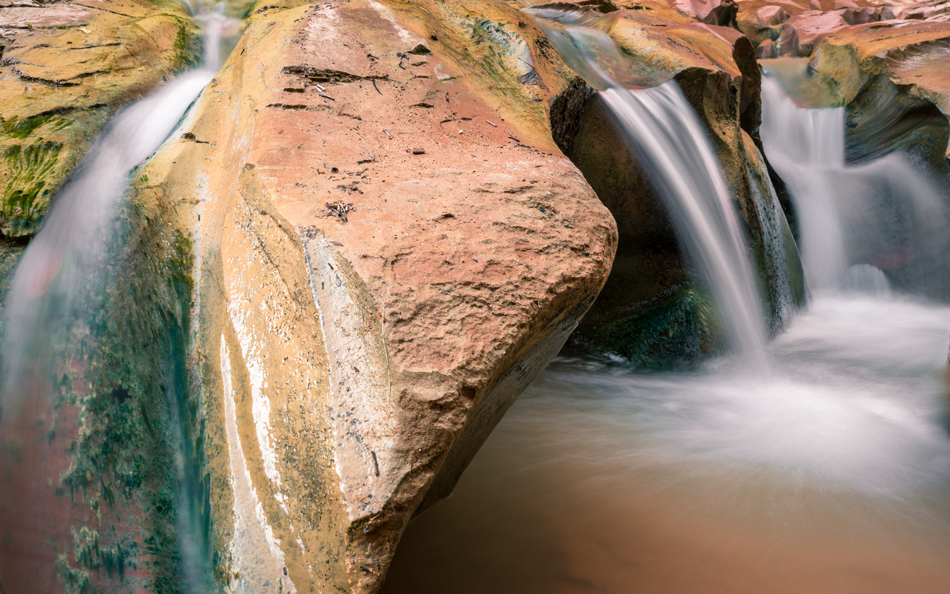
The beautiful Navajo Sandstone canyon walls, the sparkling streams, two arches, a natural bridge, Indian pictographs and several waterfalls made this my all favorite spot in the Grand Staircase Escalante National Monument.
It is easy to understand why this inspiring canyon is the most popular hiking destination of all canyons of the Escalante. Consequently, you will encounter a number of other hikers in Coyote Gulch during spring and fall time.
I strongly recommend anyone to spend 2-4 nights backpacking. Take your time and take in the full experience the canyon and its adjacent canyons has to offer.
Practical Advices:
A day-hike or a multiple days backpacking to Coyote Gulch is not an easy project. Coyote Gulch should not be at the top of your to-hike-and-to-photograph-list if you do not have any experience with backcountry hiking. You REALLY need experience in surviving in nature. It is imperative to know what kind of equipment is the right for such an endeavor. Rather than going to an outdoor store and relying on what the sales person recommends you, you should gather experience by learning stepwise with each hike until you are ready for Coyote Gulch. The alternative is joining someone who has the experience and is able to guide you securely through such an adventure.
Backcountry permits are easily obtainable. You can acquire one at the trailheads of Red Well, Hurricane Wash and Fortymile Ridge (see below) or at the Visitor Center in Escalante.
You can camp anywhere in the canyon. The most popular spots are between Jacob Hamblin Arch and the Natural Bridge.
Campfires are not allowed in the Glen Canyon National Recreation Area.
Water is easily accessible throughout the entire canyon almost year-round, but you will need to purify it.
Autumn is my favorite time of the year to visit and photograph Coyote Gulch. The colors of the vegetation vary from bright yellow to deep reds and give a fantastic contrast to the sandstone walls. Spring is very beautiful too. The vegetation has a very fresh green to it. During the winter, temperatures can drop below freezing and even receive snow. I do not recommend Summer for various reasons: EXTREME heat, flash floods and deer flies.
For current conditions call the Escalante Interagency Visitor Center (435-826-5499).
Getting to Coyote Gulch:
There are several possibilities of entry and exit into and out of Coyote Gulch. Each entry and exit point has its advantages and disadvantages. Regardless of which route you choose your trip should start at the town of Escalante. Take UT-12 eastbound for about 5 miles. Enter onto Hole-in-the-Rock Road to your right.
Red Well and Hurricane Wash trails: Drive from the beginning of the Hole-in-the-Rock road about 31 miles, turn left on Red Well road (BLM254). In about a mile you will arrive at the Red Well trailhead parking area.
The Hurricane Wash trailhead parking area is 34 miles from the beginning of Hole-in-the-Rock road.
Both of these trailheads begin in wide, sandy washes before transforming into narrow canyons with towering walls. Although the first section can be hot and dry, water begins to flow a couple miles into the hike. Roughly 7 miles from the Red Well trailhead and 5.5 miles from the Hurricane Wash trailhead, you will reach the confluence of Coyote Gulch and Hurricane Wash. From here it is about 1.5 miles to Jacob Hamblin Arch and 7.5 miles to the Escalante River. The confluence of the Escalante River and Coyote Gulch is a stunning place with great view of Steven’s Arch.
Fortymile Ridge Trail: This is my favorite and most used trail to enter into Coyote Gulch. To access the trailhead you drive on Hole-in-the-Rock road 36 miles until you turn left on Fortymile Ridge road (BLM 270). The remaining 7 miles is a very sandy trail which might impose some serious problems for an ordinary passenger car. Thus, I really recommend it only for people who has a high clearance and 4×4 car.
The Fortymile Ridge trailhead has two possible entries into Coyote Gulch. Either hike northwest to Jacob Hamblin Arch or northeast to Crack-in-the-Wall and the Escalante River. Personally I do not recommend getting into Coyote Gulch via Jacob Hamlin Arch (see below). The two miles hike from Fortymile Ridge Trailhead to Crack-in-the-Wall and another mile to the Escalante River is the much easier alternative. This route can be hard to follow; however, the trail is nearly a straight line and the destination is an easy find. You can see the confluence of Coyote Gulch and the Escalante River from the trailhead parking lot. Mark this compass bearing before heading out. The view will disappear as you begin to lose elevation. The compass bearing will make the traverse of the dry desert plain and easy task.
Soon you will reach the famous Crack-in-the-Wall. This is a narrow passage, peeled away from the cliff face on huge rock slabs. The crack is about 18 inches wide, forcing hikers to walk sideways, and 50 feet long. Crack-in-the-Wall can be difficult to climb down (and even harder to get up). Hence, having a long rope with you to descend your gear gently on the outside of the crack will safe you a lot of time and headache. The crack might be too tight for you to squeeze through your stuff. After scrambling down through this crack, a trail leads down a sand dune to Lower Coyote Gulch and the Escalante River. To make a loop hike, you may choose to hike upstream the gulch and out of the canyon near Jacob Hamblin Arch and finally back to Fortymile Ridge trailhead.
Jacob Hamlin Arch: There is a in-and-out sneak route of Coyote Gulch at about half-way point, near Jacob Hamlin Arch. It is tempting to use this sneak route as an exit. It allows you to hike Coyote Gulch from the Fortymile Ridge trailhead as a day hike with plenty time inside the canyon. However, it should not be undertaken if you have loaded up a lot of photographic and camping gear, unless you have a rope and you are an experienced climber to boot. Agile day hikers with good scrambling skills and no fear of heights can rather negotiate the climb without to much difficulty. Nevertheless, extreme caution is required. You undertake this climb on your own risk, knowing that if you slip or fall you can get badly hurt. It is even more dangerous to use this route to descend into Coyote Gulch. Hence, I discourage it!
The hike and the photographing are done. I have a final recommendation you. Stop in Escalante and get spoiled. Have a well deserved and refreshing shower and indulge yourself with a delicious meal at Escalante Outfitters. These two so fundamental elements of life never will feel so good.
Photographic advices:
Coyote Gulch has endless photographic opportunities to be explored along. Enter the canyon rather well equipped, than regretting it later on having left any essential gear at home or in your car. Consequently this will add a lot weight to your backpack. Hence I really recommend you to plan this adventure as a multiple backpacking day. Carry all your photographic and backpacking stuff into Coyote Gulch on your first day. Find a spot which will be your base camp. From there you will do your several days excursions. All the non-essential elements are left at the base camp rather than carrying them around all day. This kind of strategy will allow you to move faster and lighter through the different portions of the canyon. Use your energy to be creative in your photography.
Any kind of lenses (wide-angle, normal range, telephoto) can and should be used. The variety of lenses will give ample creative possibilities.
The use of a polarizing filter is almost mandatory. Avoid glares on the canyon walls and unwanted reflections on the water too.
Do not leave your tripod at home or in your car. You really will need it!
Additional Recommendation:
A visit to the Sunset Arch should be mandatory and included at your Coyote Gulch hike. Both locations are very close. Have a look at my Sunset Arch travelogue for easy guidance.
Last update: August 6, 2013
