- Destinations
- Washington
- Mount St. Helens NM
On May 18th, Mount St Helens erupted and transformed the surrounding forest into a devastated landscape of mud, ash, lava, and scattered logs that once were trees. 31 years later, roads and buildings have been rebuilt, and nature is reclaiming what once belonged to it. New growth and wildlife is returning to this once very barren landscape.
Planning a Trip to Mount St Helens:
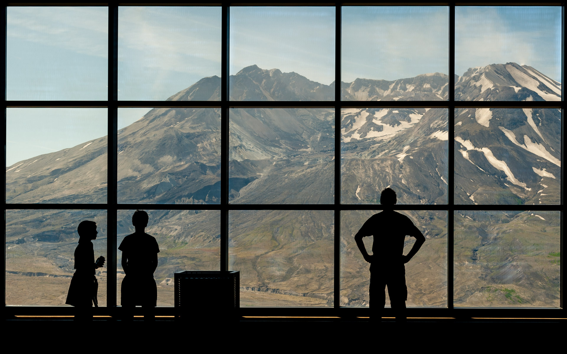
The park can be approached from the west, east or south side of the mountain. The Mount St Helens main visitor center is at Silver Lake on the west side and is the best area for a first-time visit. This is a large park and there is no through road in the monument, so you will want to plan separate excursions to the east, west and south side of the mountain.
All areas of the park are open from mid-June to Labor Day. The west side access is open all year. Snow starts falling east and south side around end of October, closing the roads sometime in November. The roads are usually open by Memorial Day.
If you have a day, concentrate on the Spirit Lake Memorial Highway, where you will find excellent view of the volcano, the moonscape-like landscape and possibly some wildlife. The best view of the mountain from the road are at Coldwater Ridge and Johnston Ridge at the end of the highway. Allow at least three hours – an hour to drive in, an hour to take photographs, and an hour to drive back. This is the only road open during the winter. Try to be at the end of the road in the morning or afternoon when there is side-lightning on this south-facing view.
If you have a second day, put the east side on your list. This is excursion will require a full day. Allow three hours driving time to reach Windy Ridge.Drive directly to Windy Ridge, which is the best viewpoint of the mountain, and then work your way back stopping at the viewpoints and taking short hikes as you time permits. Try to get to Windy Ridge early in the morning for good light on the mountain.
If you have a third day, consider exploring the south side of the monument next. Stop at Lahar Viewpoint and a hike into Lava Canyon. If you love photographing waterfall, spend your time along the Lewis River.
Photographing Mount St Helens:
There is so much to photograph here including views of Mount St Helens, the devastated landscape, wetlands, lakes, wildlife, and wildflowers. The blast area, mudflows, and lava-covered landscape look like another planet. Some very interesting photos can be taken of life emerging from the shattered landscape. Each year everything gets a little greener and new trees grow a little taller. Wildflowers have been particular successful in the open environment. The new greenery has attracted herds of elk and the open landscape makes it easier to photograph them.
The best photographs of Mount St Helens are taken from the south-facing views looking into the blasted-way side of the volcano. Early mornings or late afternoons are going to be the best times to photograph the volcano for side-lightning. In fall and winter you will be facing toward the sun at mid-day, a difficult situation for photography. Photographers can take excellent photos traveling the roads, stopping at viewpoints, or taking some of the short hikes. The best views on the west side are from the Coldwater Ridge and Johnston ridge viewpoints. You are very close to the volcano in the blast zone looking directly into the heart of the crater. On the east side the Windy Ridge viewpoint is best. Forest Road 99 to Windy Ridge has several stops with good views of Mount St Helens and Spirit Lake.
More ambitious photographers can take the longer and more strenuous hikes or even backpack into the monument. Some of the best views are from the trails that travel the ridges north of Mount St Helens. You are little farther away from the mountain and you are more likely to find interesting foreground to add some depth to your photos. Photos from the viewpoints are often limited to straight panoramic shot of the volcano.
Gritty fine particles of volcanic ash can ruin your camera and lenses. If you are going to do any hiking int he blast area, make sure you pack your camera and gear in plastic bags and keep them in a tight-fitting camera bag. Keep your camera in the bag until you are ready to use it, especially if there is any breeze. Bring a soft brush for dusting off your camera and lenses before putting them away.
Wildlife:
Although much of the animal life died during the eruption of the volcano, the new generation has attracted back much of its former wildlife. Deer and elk have returned in large numbers to the Toutle Valley on the west side of the park and can often be photographed right from the road. Elk are especially abundant in this area during the fall and winter months. Other good places to photograph elk are around Clearwater on the south side of the monument.
There are many small animals in the parl. They include gophers, squirrels, chipmunks, marmots, red fox, coyotes, beavers, and more.
Wildflowers attract hummingbirds and good places to find them along the trails over Norway and Independence passes in the summer. The Silver Lake wetlands and the Goat Marsh area are a good place to find waterfowl and other birds.
Wildflowers:
The devastation caused by the volcano opened up wide expanses and the first plants to take advantage of the situation were the wildflowers. These plants can thrive in the open ash-covered areas and return nutrients to the soil. The first were the red fireweed followed by the lupine. other wildflowers doing well include aster, avalanche lilies, bleeding hearts, penstemons, bunchberry, and monkey flowers. Not only can you photograph masses of flowers but you can take photos of the great contrast of the colorful and delicate wildflowers against the drab and harsh landscape left by the eruption.
You will find wildflowers all over the monument, but some of the best destination include the Meta Lake, Independence Pass, and Plains of Abraham trails. On the lower slopes of the mountain you can photograph avalanche lilies in late spring to midsummer.
Coldwater to Johnston Ridge:
Arriving at Coldwater Ridge is like arriving in a different planet. You get out of the car and you are in a moon-like landscape. From the deck of the visitor center you have views of the volcano, the newly formed lakes and the debris-filled Toutle River Valley. From this vantage point Mount St. Helens rises from the pumice plain just seven miles away and you are looking into the crater through the blasted side. The quarter-mile Winds of Change Trail follows the ridge just west of the visitor center. There are exceptional views from the trail of Mount St. Helens and the Toutle River Valley.
Continue along the road another two miles from the visitor center where it drops down the lake and turn to the picnic area and boat ramp at the west end of Coldwater Lake. From the picnic are you can take the easy boardwalk Birth of Lake Trail out over Coldwater Lake. From the boat ramp, the Lake Trail follows the north shore of the lake. It is three miles to the east end of the trail. Along the way you will encounter fields of wildflowers in summer.
Drive a little farther and on the right is the parking area for the Hummocks trail. This is a 2.3 miles loop trail that takes you through the devastating landscape of ash, rocks, over hummocks formed by landslide, past ponds and meadows, and views of the Toutle Valley and Mount St. Helens. There is a good overlook just a short distance along the trail. Elk may also be seen in this area.
The Boundary Trail also leaves from here. You can hike part of this trail four miles to a viewpoint above the hummocks. You can also reach the viewpoint via a 0.8-mile trail from Johnston Ridge.
Johnston Ridge Observatory:
The road then climbs to Johnston Ridge, seven miles from the Coldwater Visitor Center. Here you are only five miles from Mount St Helens and you have spectacular views of the crater, the streaming lava dome, the pumice plain and landslide. From the observatory you can walk the 0.3-mile Eruption trail to an overlook and then along the ridge back to the parking area. This is a good spot to photograph the volcano and the barren landscape.
Windy Ridge:
From this viewpoint you have a view of Mount St Helens in the pumice plain and the west end of Spirit Lake with Johnston ridge beyond it. A 15-minute walk via stairs takes you to a higher trail through a blown down forest to a ridge. From the ridge you have a panoramic view of Mount St Helens and Spirit Lake and from this vantage point you are looking directly into the steaming crater.
More ambitious hikers can hike the Truman Trail to the Plains of Abraham. This is a four-mile strenuous hike. The trail drops down through the blast zone along the south side of Windy Ridge to the pumice plain and then to the Truman_Abraham Saddle. It then climbs a ridge with some great views. A series of sand ladders helps you climb the soft pumice. Hike as far as you feel comfortable. There are several longer trails that continue on from here for the backpacking photographer.
Last update: October 26, 2011
Disclosure: The first image does not belong to me. It was retrieved from the internet after a quick search and was presented originally by NBC News.
The text is an exert out of “Photo Traveler’s Guide to … Mount Rainier & Mount St. Helens National Park”. The full hard copy version can be purchased here.